

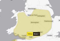
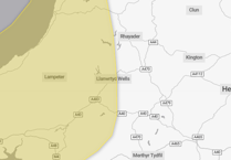
The Met Office has upgraded a yellow weather warning over Mid Wales for snow to an Amber warning as Storm Goretti is set to hit the country.


The heavy snow associated with the storm is likely to lead to disruption and dangerous travelling conditions on Thursday night and into Friday.
A spokesperson for the forecaster said: “Rain associated with Storm Goretti will turn readily to heavy snow on Thursday evening, initially on hills and then to lower levels overnight, before easing through the course of Friday morning. Accumulations of 10-15 cm are likely fairly widely, with the potential for 20-30 cm in some locations, mainly on hills above 200 m elevation, more especially in Wales.
“Snow will ease through the course of Friday morning, turning more to rain or sleet at times at low levels, but disruption is likely to persist into Friday after snow stops falling.
“There is some uncertainty over the exact track of Storm Goretti, which will influence the locations most likely to see disruptive snow, and it is possible this warning may be updated.The low pressure system has been named by Meteo France, as the strongest winds associated with Storm Goretti are most likely over northern France.”
The Met Office’s warning impact matrix shows that the storm will have a high impact and is likely to take place.
Comments
This article has no comments yet. Be the first to leave a comment.